


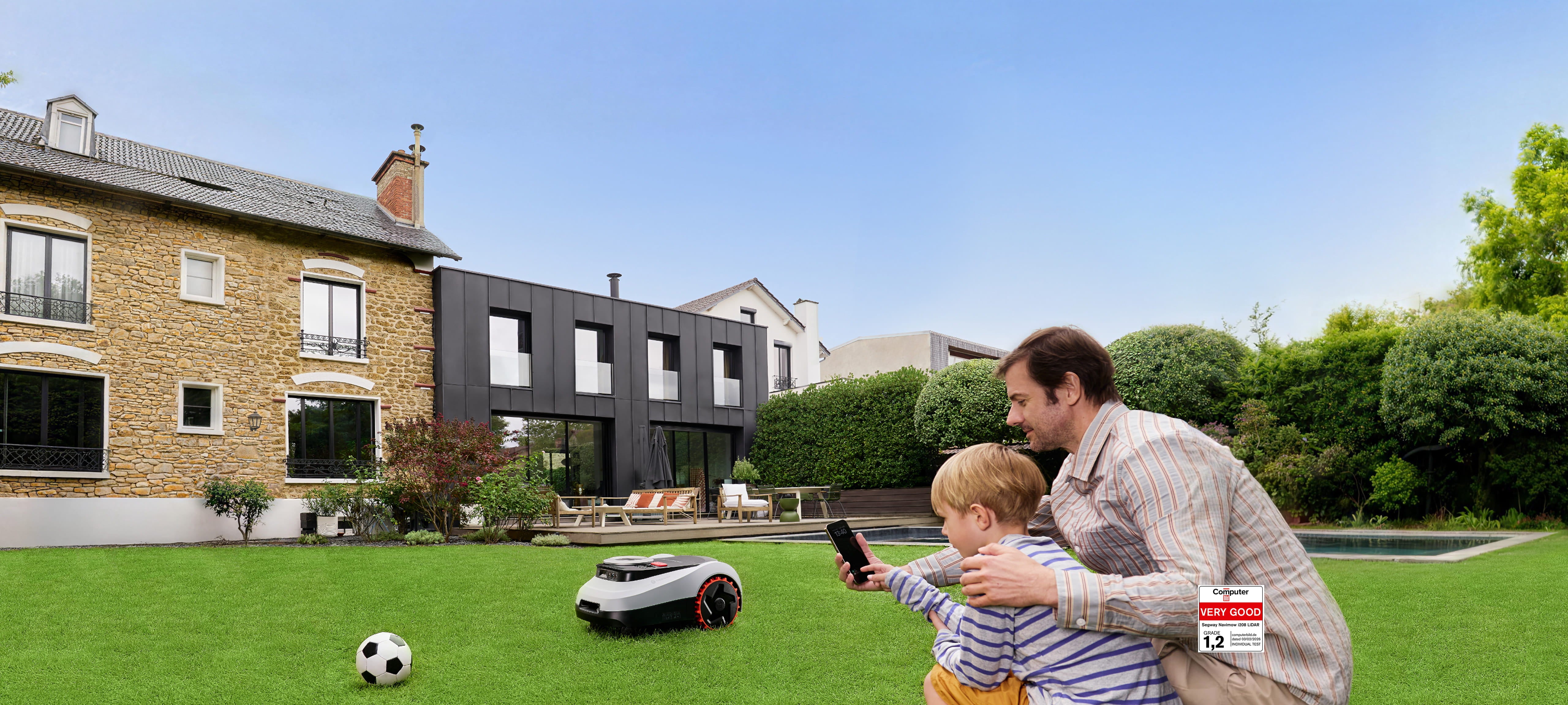

Drop and Mow
Setup in minutes. Automatic mapping

EFLS™ LiDAR
LiDAR + Vision dual fusion system

GeoSketch™
Real-scene map editing

VisionFence™
AI avoids 200+ obstacles with 1cm precision

Enhanced Slope Mowing
Off-road wheels, slopes up to 45% (24°)¹

EdgeSense™
Ride-on boundary cutting

59dB(A)
Quiet Operation
IP66
Water & Dustproof
3-Year
Up to 3-Year Warranty

Quad-Layer Security System
24/7 protection, always-on tracking
Enhanced Slope Mowing
Off-road wheels, slopes up to 45% (24°)¹
GeoSketch™
Real-scene map editing
EFLS™ LiDAR
LiDAR + Vision dual fusion system
Drop and Mow
Setup in minutes. Automatic mapping
EdgeSense™
Ride-on boundary cutting
VisionFence™
AI avoids 200+ obstacles with 1cm precision
Quad-Layer Security System
24/7 protection, always-on tracking
59dB(A)
Quiet Operation
IP66
Water & Dustproof
3-Year
Up to 3-Year Warranty


GeoSketch™
A True-to-Life View of Your Yard
Generate vivid, real-scene maps in the app. Edit boundaries visually,
adjust edges, and fine-tune your mowing plan with intuitive, point-and-tap controls.
Satellite-Free Navigation. Unshakable Accuracy.
Navigate with Absolute Confidence.
Powered by our industry-leading EFLS™ LiDAR (LiDAR and Vision) dual fusion, i2 LiDAR creates its own reliable navigation network without depending on satellites. Positioning remains stable even in challenging scenes.
Navigates confidently through 70cm passages
LiDAR-based mapping handles dense canopies with no dropouts
LiDAR maintains identical performance in total darkness. Unwavering accuracy day or night


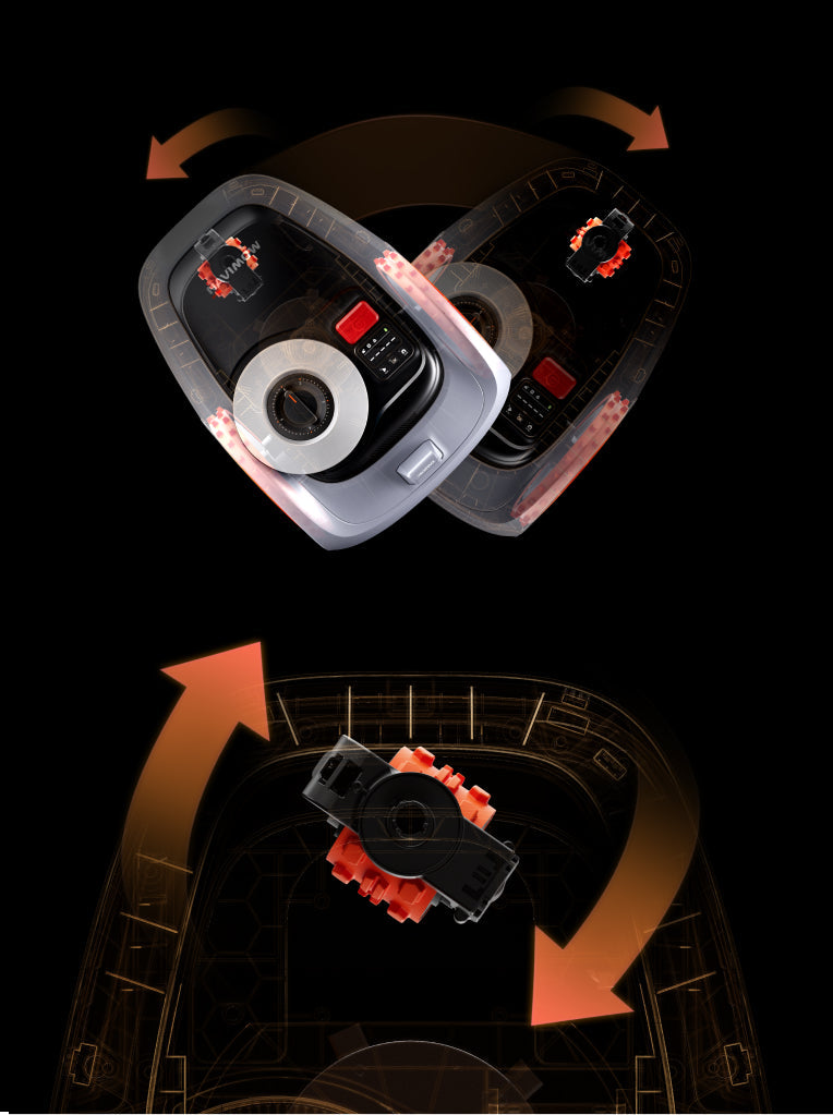
Next-Gen Ultimate Design: Solid-State LiDAR
Unlike mechanical LiDAR with fragile rotating parts, solid-state LiDAR has no moving parts. Designed for embedding into systems, it offers a robust, and long-lasting solution.


· External LiDAR are prone to scratches
· Rotation structure are less durable
· Embedded, scratch-resistant design
· No fragile rotating parts
· 60+ reliability tests passed
· 50G vibration-shock resistance for long-term durability
VisionFence™
LiDAR + Vision, Advanced Perception. 200+ Obstacles Avoided.
Precision beyond limits, awareness without bounds. Safeguarding every creature and clearance.
From chair legs to children’s toys, i2 LiDAR detects small objects with remarkable accuracy for seamless navigation.
3D LiDAR perception recognizes overhead risks (swings, trampolines, even car undercarriages) and only passes when clearance is safely confirmed.
Detects over 20 animal types from a distance of 1 meter or more, slows automatically, and maintains a cautious buffer throughout operation.


Slopes? Mastered. Off-Road Wheels + Electronic Stability Control
ESC actively regulates wheel motion to maintain a stable center of gravity. Combined with high-grip off-road wheels, the i2 LiDAR climbs and turns on 45% slopes with confidence.¹

Tough on Grass
A 100W peak-power motor and 6-blade cutting disc slice through dense grass and hardy weeds without hesitation.

EdgeSense™ for Seamless Borders
Edge trimming reaches up to 5 cm from boundaries, while ride-on cutting ensures smooth transitions and clean edges along walls, fences, and pathways, minimizing manual trimming and delivering a near-perfect finish.
Master Every Corner of Your Lawn
Easily auto-map disconnected lawn areas and integrate into your existing map with Navimow's Isolated Zone Mapping feature. Plus, freely share your mower and app experience with neighbors without privacy concerns, with full control over shareable data.
Customize mowing height, schedule, and patterns across up to 20 separate areas, all from the app.


Always Tracked, Always Protected
24/7 protection — even when powered off or offline.
Geo-fence alerts
Lift alarm
GPS tracking
Apple Find My support

59 dB(A) Whisper-Quiet Operation³
Peaceful mowing that blends into your garden’s ambiance.

Unleash Your Creativity
Use the 26 letters and a range of preset shapes to turn your lawn into a personal canvas.

Extreme Weather Ready
Automatically pauses and returns home during heavy rain, frost, snow, strong wind, or extreme heat.

Engineered for Resilience
Safely stores and operates between -20°C to 50°C without performance loss.
Built tough to save you time. Maintenance as simple as a rinse.


Spec & Compare
1. Measured under test conditions with 5 cm grass height, dry grass surface, and a slope free of obstacles.
2. Mapping Area: Supports map storage up to 1.2× the recommended mowing area (e.g. up to 1200 m² for a 1000 m² model). Actual mappable area may vary depending on yard layout and complexity.
3. Noise Level: Measured under laboratory no-load conditions, drive motor operating at 0.5 m/s, motor at 2500 rpm, without cutting.